
A friend and I had a pleasant afternoon walking to the summit of Mount William in the Grampians, Victoria and both took a lot of photos.
Back in 2006, a large fire started in the Mt Lubra area and burnt most of the area that we travelled and walked. Looking at the vegetation you could hardly see the impact. Vegetation was quite thick and small trees that were encroaching the road have been pruned back to allow for the safe passage of vehicles. In January 2011, extremely wet conditions were experienced and extensive flooding occurred. The scars from Rock slides were still visible today.

Getting There
It was a pleasant drive on bitumen road from Halls Gap heading south on the Grampians Road. We past other attractions in the Grampians such as Brambuk, Lake Bellfield, the turn off to Silverband Falls and a Camp site called Borough Huts. Just past Borough Huts, we took the turn to the left which was a little windy, but bitumen road for about 10 kilometres to the Mt William car park. There are few places to stop and take photos, but worth taking the time to stop, find some higher places along the road to get some visibility over the trees.
Walking from the Car park to the Summit of Mt William
The walk from the Car park to the Summit is classed as strenuous. The walking track is the road used for Park Management and for access to the Telecommunication Towers that are near the summit of Mt William. I must say that the first section of the walk is quite steep. There is plenty of birdlife and plants if you keep your eyes open.

The outcrops of rock are very similar to other locations in the Grampians.

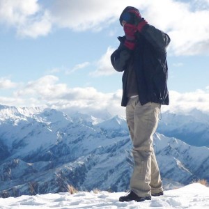
What to see at the Summit
The view from the summit of Mt William is spectacular. The day we did the walk was quite fine with a small amount of haze. Looking past Redmans Bluff you can see Lake Fyans and Lake Lonsdale. Looking towards the west we looked over the Sierra Range including Mt Lubra where lightning struck causing a major fire in January 2006.

Looking south, we can see the range right down to Mt Abrupt and a little further to the east, the wind farm near Glen Thompson can also be seen. Looking towards the east, we could see Mt Ararat, Mt Langi Ghiran, and Ben Nevis.
Towards the North, we could see the Black Range and just in the distance, the City of Stawell.
Towards the North West, we could see the Mt Difficult Range and the township of Halls Gap. We could just see part of Lake Bellfield which is near Halls Gap.

For more information about Mt William